![]()

Anthropogenic Impact Assessment on Elephant Habitat: A Geospatial Modelling Approach Using High-Resolution Pleiades Data in Sai Yok National Park
Author | Dr. Anirban Mukhopadhyay (Kazimierz Wielki University / Asian Institute for Technology)
- Ecosystem management
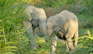
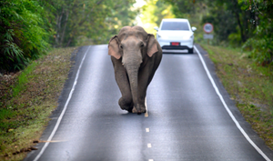
- Thailand's wild elephant population has plummeted to just 3,000–4,000 individuals, a stark contrast to the estimated 100,000 that roamed freely at the start of the 20th century. Expanding human settlements and habitat degradation have intensified human-elephant conflict, posing a serious threat to their survival.
- The project utilised high-resolution satellite imagery and AI to create detailed maps identifying habitat degradation and human activity in and around Sai Yok National Park, informing sustainable land-use strategies for elephant conservation.
- The project also explored the most effective machine learning models for analysing high-resolution satellite data to assess habitat quality and connectivity.
- SVM, Random Forest, CNN and CART were applied for land-use classification, with SVM yielding the highest accuracy (92%).
- Field data was collected to validate the results and refine the methodology for broader application across larger areas.
- For further insight into the performance of various machine learning models and their potential for habitat assessment, read this article.
Objectives
2. Assess the degradation, vulnerability and risk of elephant habitat in the park.
3. Identify the main drivers of habitat degradation through habitat modelling.
Introduction
The continents of Africa and Asia are home to elephants, the biggest land animal on the planet. However, these majestic creatures are not immune to dangers, with habitat loss and human conflict ranking among the most serious hazards to their long-term existence. Human-Elephant Conflict may intensify due to habitat loss, degradation, and climate change. Human settlements and agricultural land grew throughout Africa and Asia over the past century, particularly from the late 19th century onwards, resulting in considerable degradation of elephant habitat and a major drop in elephant numbers compared to their natural abundance and range. Elephant populations are now living in closer proximity to human settlements due to dwindling habitat, leading to resource conflicts, crop raids and human casualties. In addition, climate change is causing changes in elephant habitat distribution based on food and water availability. The Intergovernmental Panel on Climate Change (IPCC) predicts that if global temperatures exceed 1.5 or 2 degrees Celsius, between 32% and 46% of free-ranging wild species could face severe consequences, including the loss of up to 30% of their current habitat. In addition to habitat loss, these species may experience reduced access to food, altered migration patterns and increased exposure to disease and extreme weather events.
Over the last century, the number of Asian elephants has dropped from 100,000 to just 7,000 surviving by 2018. According to recent research, the population of Thai elephants has been reduced to roughly 3000-4000 wild elephants, with the majority located in terrestrial forest complexes throughout Thailand's western and eastern regions. To improve conservation efforts for Thai elephants, it is essential to try to project climate change and land conversion scenarios and analyse their impact on the distribution of suitable habitats. Therefore, our research was focused on elephant habitat modelling and habitat quality assessment in Sai Yok National Park, which is part of the Western Forest Complex (WEFCOM), a massive continuous forest tract covering approximately 18,730 km2 and consisting of 19 protected sites across Thailand and Myanmar.
Methodology and Analysis
Data
One of the most important aspects of this research was to utilise Very High-Resolution (VHR) Pleiades’ 1A Multispectral Imagery. The “High-Resolution Imager” (HiRI) in Pleiades’ sensor acquires imageries utilising a single Panchromatic (PAN) band and four Multispectral (MS) bands with a radiometric spectrum ranging from 430 to 940 nm (Blue: 430–550 nm; Green: 500–620 nm; Red: 590–710 nm; and Near Infrared: 740–940 nm). The Pleiades’ sensor is intended for a variety of high-resolution remote sensing applications in the areas of cartography, geology, forestry, agriculture, hydrology etc.
Feature extraction
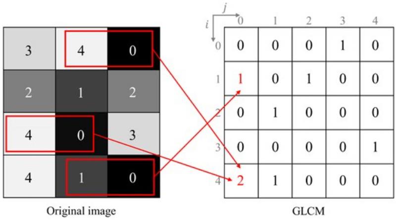
Grey Level Co-occurrence Matrix (GLCM) was used to perform feature extraction from Pleiades imagery. The extracted features together with Normalised Difference Vegetation Index (NDVI), Normalised Difference Built-up Index (NDBI), Normalised Difference Water Index (NDWI), and Population index were utilized in the image classification process to improve the accuracy and quality of the classification results.
Machine learning models
Land use and land cover (LULC) mapping of the Sai Yok national forest was conducted using four machine learning-based algorithms to assess the influence of changing land use on habitat degradation and the risk and vulnerability of the elephant habitat. The algorithms included Support Vector Machines (SVM), Random Forest (RF), Convolutional Neural Network (CNN), and Classification and Regression Trees (CART). The performance of these algorithms was based on accuracy and their ability to differentiate classes with similar spectral signatures. Overall, the algorithms performed well in LULC classification with feature extraction compared to classification without feature extraction. SVM achieved the best results with 92% accuracy while CART achieved the lowest accuracy of 85%.
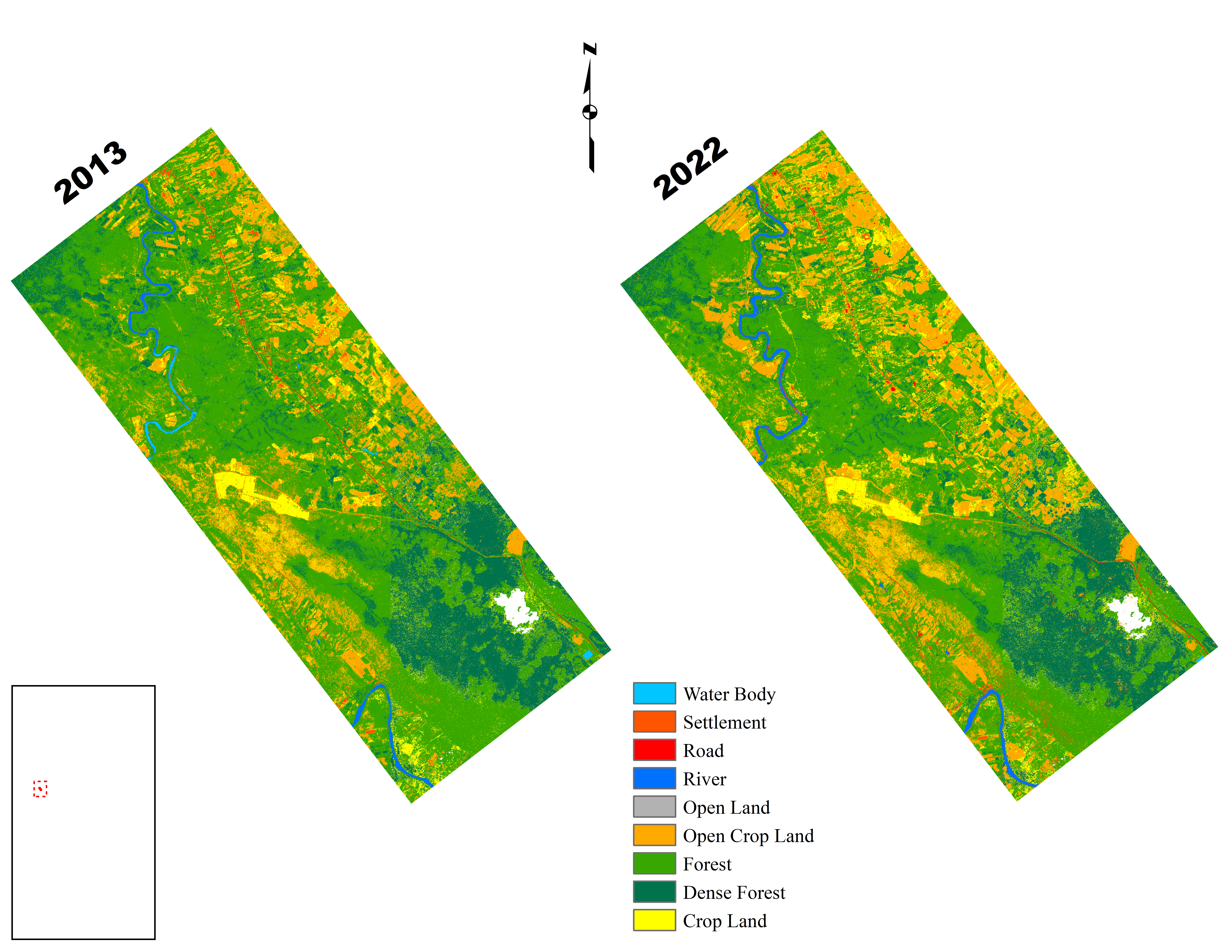
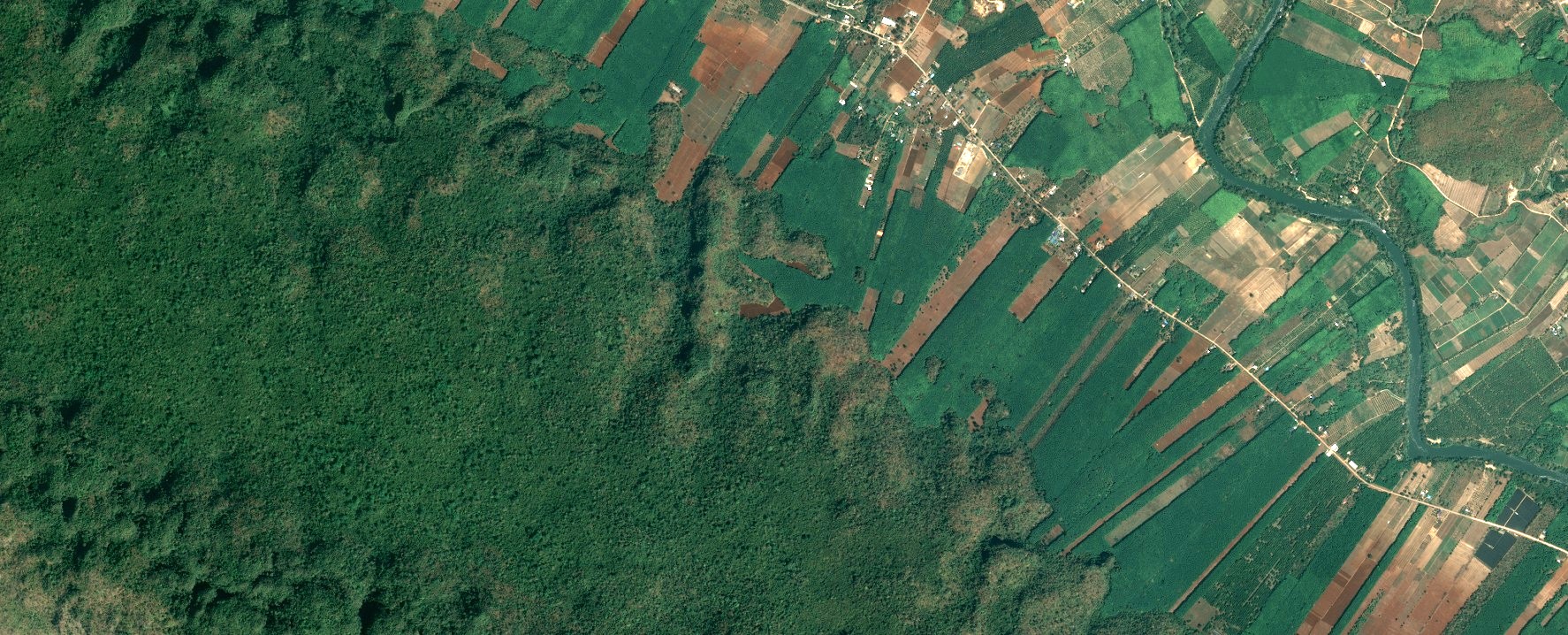
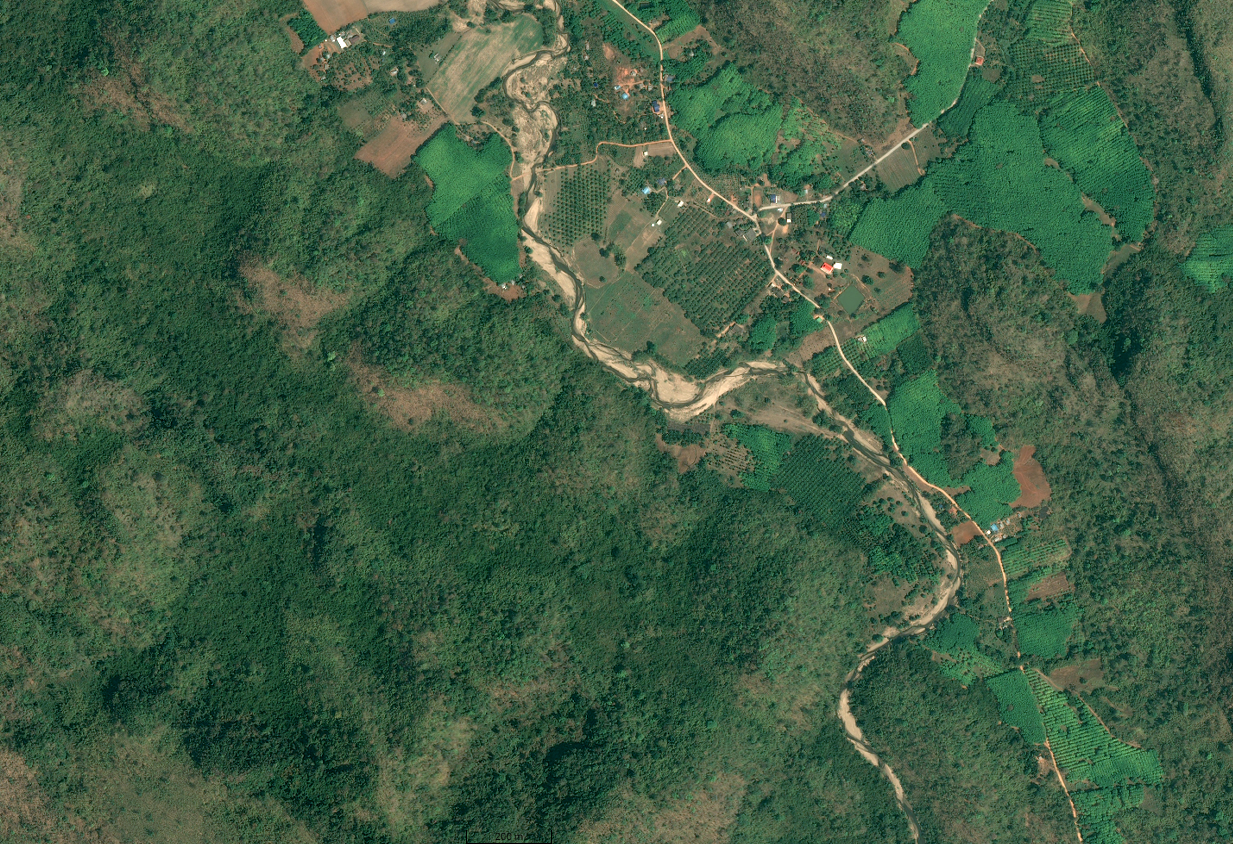
Figure 1: Land use and land cover maps of Sai Yok National Park for 2013 and 2022
|
ML Model |
Without feature extraction |
With feature extraction |
| SVM | 74% | 92% |
| RF | 70% | 90% |
| CNN | 61 | 89% |
| CART | 54% | 85% |
Table 1: Machine Learning model performance
Figure 2: A (top)Performance of Machine Learning models without feature extraction and B (below) with feature extraction
Habitat modelling
For habitat modelling, the Integrated Valuation of Ecosystem Services and Tradeoffs (InVEST) model developed as a part of the Natural Capital Project at Stanford University was applied. The Habitat Quality Assessment (HQA) model of InVEST was used to evaluate ecological risks imposed on the terrestrial habitat of elephants by integrating diverse datasets including detailed land cover and land use maps, NDVI, NDWI, NDBI, and population indices, slope, drainage density, and elevation. The modelling also involved predicting land use changes using current land use and land cover maps to predict and quantify changes over time.
Figure 3: Habitat quality maps of Sai Yok National Park for 2013 and 2022
Field Data Collection and Validation
A comprehensive field survey around Sai Yok National Park, meticulously collected Ground Control Points (GCPs) across diverse land cover classes. In addition to data collection, we actively engaged with local community and park personnel to gain deeper insights into the complex dynamics of the area. These interactions provided valuable perspectives on the challenges posed by shifting elephant habitats and the intensifying human-elephant conflict. By combining technical field data with community knowledge, our research aimed to establish a holistic understanding of the region's ecological and socio-environmental issues.
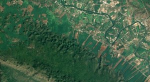
Figure 4: Field photographs of various observed land cover classes.
Results
The results obtained from our research suggest that habitat degradation has increased and intensified along the northern, north-eastern and south-eastern sections of the Sai Yok National Park. The numerous river camps, resorts, and raft homes developed along the Khwae Noi River as tourist attractions may be responsible for habitat degradation. Deforestation for agriculture and other public works projects is the main cause of habitat degradation in the southeast portion of the national park (at Ban Thung Kang Yang). As economic expansion continues and climate change-induced droughts worsen, Asian elephants may experience growing strain from both manmade activities and climate change. The future prediction model from CA-Markov chain depicts that, the northern and northeastern parts of the study area will undergo prolonged degradation.
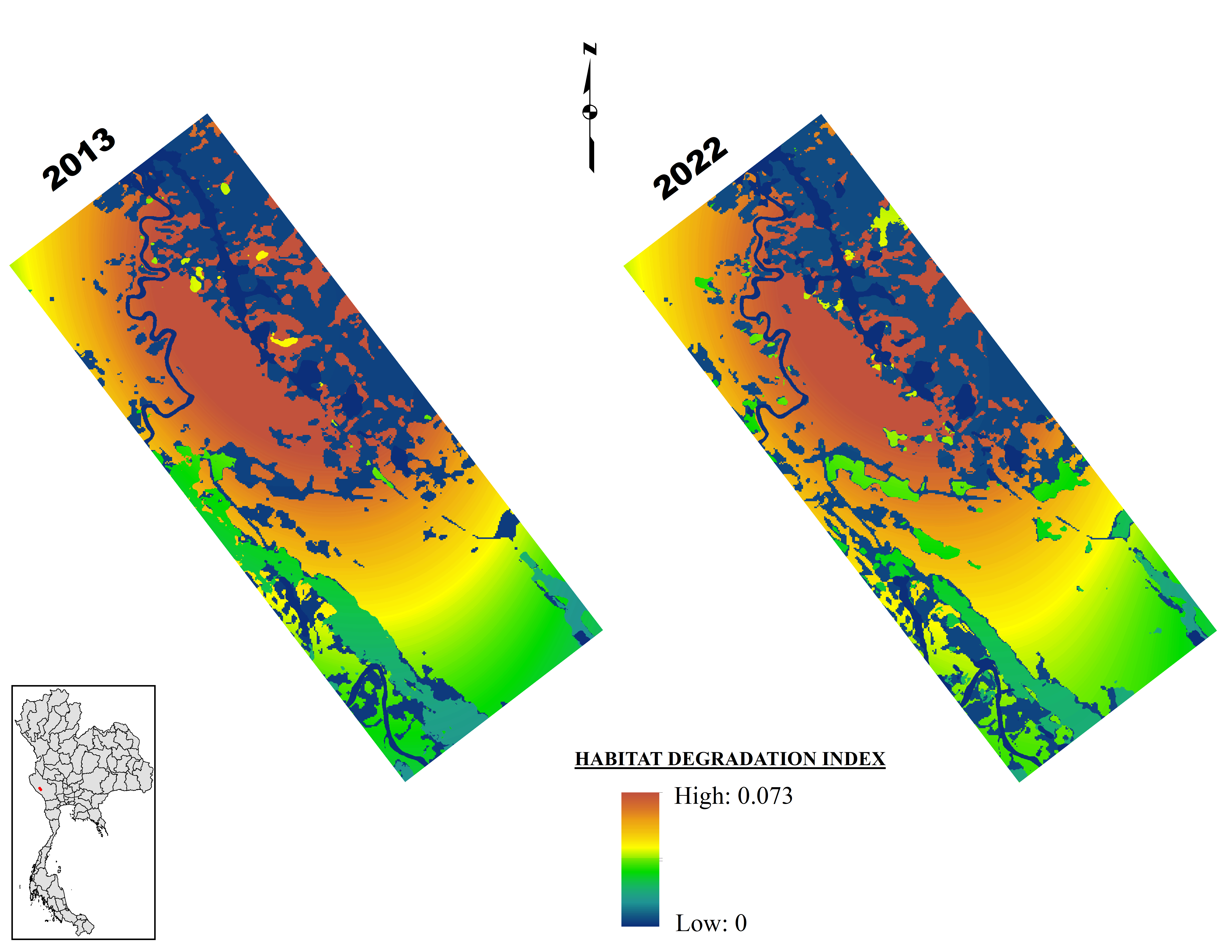
Figure 5: Habitat degradation of Sai Yok National Park for 2013 and 2022.
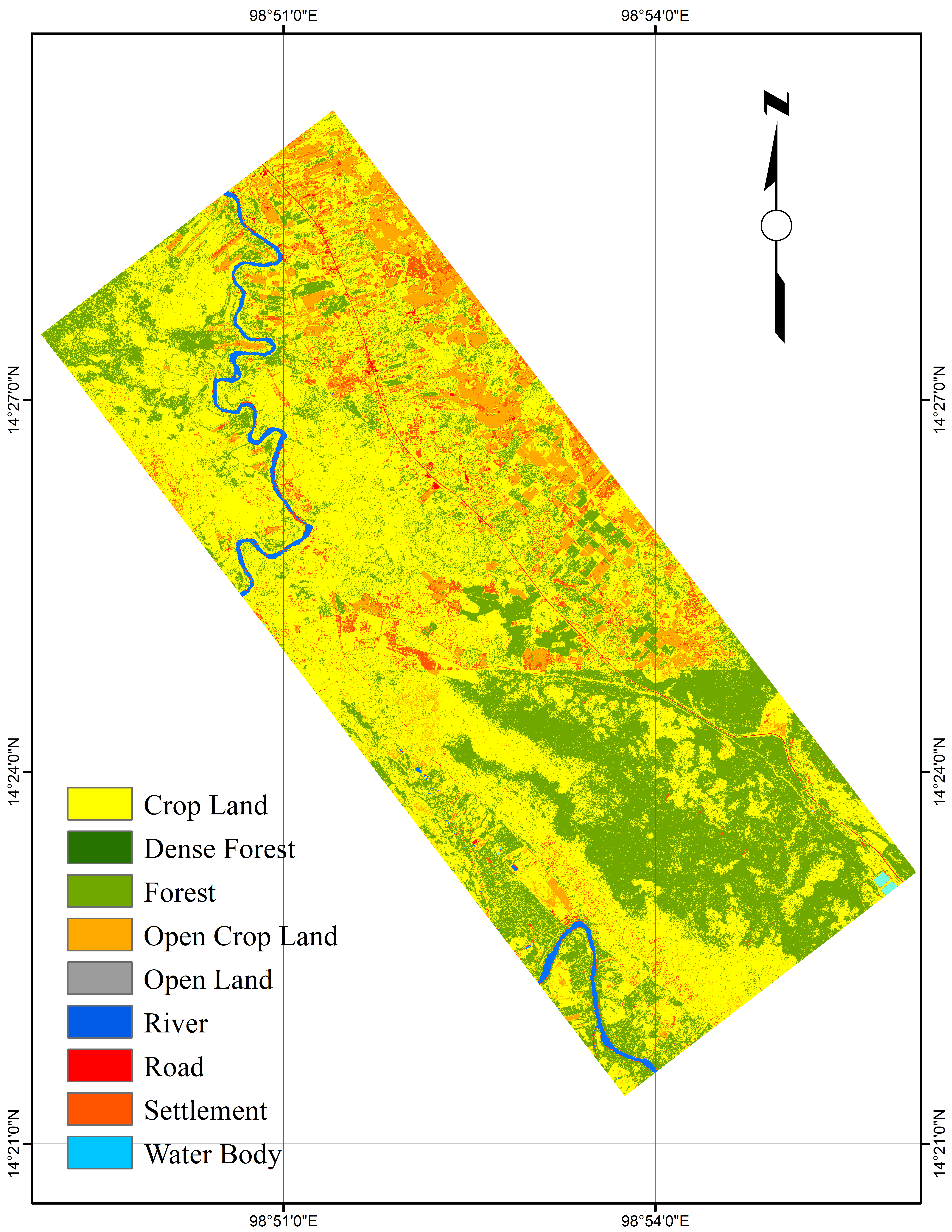
Figure 6: Land use and land classification predictions for 2050
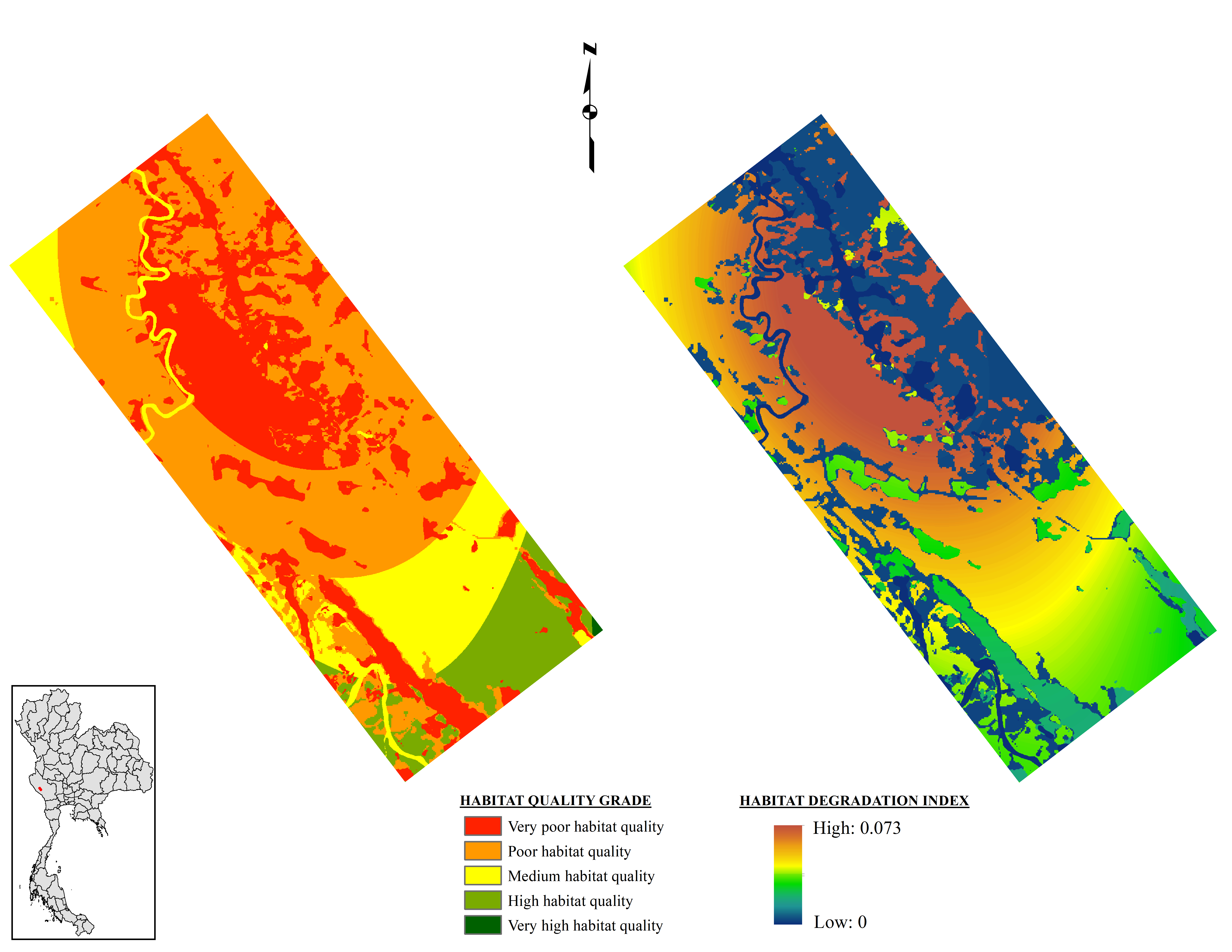
Figure 7: Predicted habitat degradation and habitat quality for 2050.
Conclusion
This study uses spatial modelling with multiple physical (elevation, slope and drainage) and socio-economic (human population, road network and urbanisation) parameters influencing the habitat of Thai elephants to assess the vulnerability and risk faced by elephants living in the Sai Yok National Park. According to our research, there has been a significant rise in habitat vulnerability and risk in the region between 2013 and 2022. Areas with high and very high risk predominate along the eastern boundary of the Sai Yok National Park, where human activity has the most influence on land use. Therefore, in Sai Yok National Park, climate change is only marginally responsible for habitat vulnerability and risk; instead, human activities are the primary drivers of these issues. These results are now being shared externally with Thai stakeholders to inform conservation strategies and guide future interventions aimed at mitigating risks to elephant habitats.
Full academic papers available below
Full study copywritten to Dr. Anirban Mukhopadhyay ( Kazimierz Wielki University / Asian Institute for Technology) and SPRINGER.
References
1. Mukhopadhyay, A., Pal, I., Pramanick, N. et al. Using Artificial Intelligence and Deep Learning Algorithms to Extract Land Features from High-Resolution Pléiades Data. J Indian Soc Remote Sens (2025). https://doi.org/10.1007/s12524-024-02077-9
2. Mukhopadhyay, A., Pal, I., Hati, J.P. et al. High-resolution Pléiades data: an in-depth analysis of applications and future prospects. Spat. Inf. Res. 32, 739–755 (2024). https://doi.org/10.1007/s41324-024-00593-x
3. "Mukhopadhyay, A., Pal, I., Hati, J.P. et al. Elephant habitat modeling in Sai Yok National Park using high-resolution Pléiades data. Landscape Ecol Eng (2025). https://doi.org/10.1007/s11355-025-00648-7"
Asian Institute for Technology
Project Lead
Anirban Mukhopadhyay
AIT is an international organisation for higher education in Thailand. They specialise in engineering, advanced technologies, sustainable development, management and planning.